ESRI

Solution Design

Why Solution Design Sets Your Implementation Up for Success

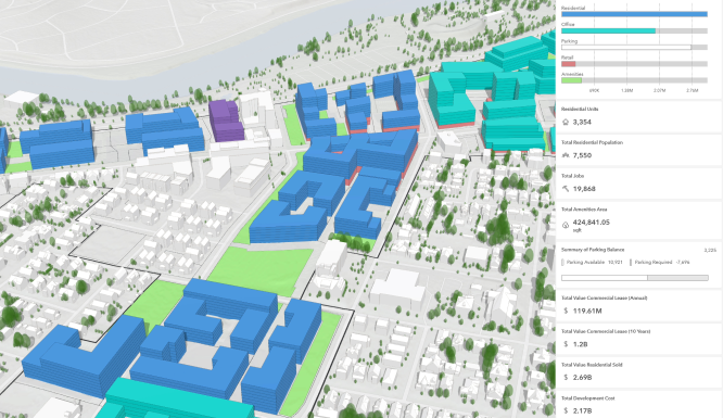
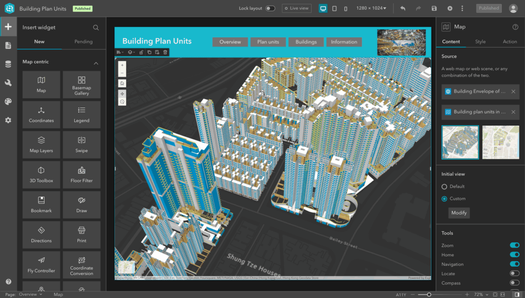
Why Solution Design Sets Your Implementation Up for Success At IMS Consulting, we know that a successful software implementation doesn’t happen by accident. It’s carefully planned. One key step that makes all the difference is the Solution Design phase. Whether you are implementing Archibus IWMS, ServiceNow Workplace Service Delivery, or an Esri solution, Solution Design […]

Why Solution Design Sets Your Implementation Up for Success Read More »

Requirements Gathering

Why Requirements Gathering Is the Cornerstone of a Successful Software Implementation

Why Requirements Gathering Is Key to a Successful Software Implementation At IMS Consulting, we believe that every great software project starts with one important step: requirements gathering. Whether we’re implementing Archibus, ServiceNow Workplace Service Delivery, or Esri-based solutions, this early phase sets the tone for success. It’s how we make sure the final system fits

Why Requirements Gathering Is the Cornerstone of a Successful Software Implementation Read More »

Needs Assessment

Why a Needs Assessment Is the First Step Toward Smarter Facilities Management

Why You Should Start Every FM Software Project with a Needs Assessment Thinking about upgrading your facilities or workplace software? Before you dive into demos or product comparisons, there’s one essential step that often gets overlooked: a needs assessment. At IMS Consulting, we believe a needs assessment is the smartest place to start. It helps

Why a Needs Assessment Is the First Step Toward Smarter Facilities Management Read More »

Esri integration with AI IoT BIM Archibus

Integrating Esri with AI, IoT, BIM & Archibus for Smarter Location Intelligence

Integrating Esri with AI, IoT, BIM & Archibus for Smarter Location Intelligence In today’s fast-paced, data-driven world, location intelligence has become more than just maps and spatial analysis — it’s a strategic advantage. Esri, the global leader in Geographic Information System (GIS) technology, has long been at the forefront of helping organizations turn geographic data

Integrating Esri with AI, IoT, BIM & Archibus for Smarter Location Intelligence Read More »

Esri GIS Facility Management

How Esri GIS is Revolutionizing Facility Management for Smarter Operations

How Esri GIS is Revolutionizing Facility Management In today’s rapidly evolving world, facility management is more than just maintaining buildings and infrastructure. It’s about optimizing space, improving operational efficiency, and ensuring the safety and comfort of occupants. One tool that is transforming how facilities are managed is Geographic Information System (GIS) technology. Esri, the global

How Esri GIS is Revolutionizing Facility Management for Smarter Operations Read More »

Revolutionizing Healthcare with Esri

Revolutionizing Healthcare with Esri GIS Technology

Revolutionizing Healthcare with Esri GIS Technology In today’s rapidly evolving healthcare landscape, location intelligence has become an essential tool for improving patient outcomes, optimizing resource allocation, and enhancing public health decision-making. Esri’s Geographic Information System (GIS) technology is at the forefront of this transformation, enabling healthcare organizations to visualize, analyze, and respond to complex challenges

Revolutionizing Healthcare with Esri GIS Technology Read More »

Esri mapping tools for data visualization

The Power of Data Visualization: How Esri’s Mapping Tools Simplify Complex Data

The Power of Data Visualization: How Esri’s Mapping Tools Make Complex Data Accessible In today’s world, data is everywhere. From businesses to government agencies, organizations collect vast amounts of data daily, but the challenge lies in transforming this information into actionable insights. The key to unlocking the potential of this data is effective data visualization.

The Power of Data Visualization: How Esri’s Mapping Tools Simplify Complex Data Read More »

ArcGIS

Leveraging ArcGIS for Enhanced Space Planning

Leveraging ArcGIS for Enhanced Space Planning In today’s dynamic business landscape, effectively managing and utilizing physical spaces is crucial for minimizing costs and maximizing productivity. Esri’s ArcGIS suite of Geographic Information System (GIS) software products helps organizations analyze, visualize, and optimize their floorplans, buildings, and campuses in ways that traditional tools cannot match. By transforming

Leveraging ArcGIS for Enhanced Space Planning Read More »

Coral Reef - Conservation

Using Esri to Enhance Environmental Conservation Efforts

Using Esri to Enhance Environmental Conservation Efforts: Tracking Wildlife Populations and Habitats with GIS In an era where environmental conservation is more critical than ever, leveraging advanced technologies can make a significant difference. Geographic Information Systems (GIS) have emerged as powerful tools in the quest to protect our planet\’s biodiversity. Esri, a leader in GIS

Using Esri to Enhance Environmental Conservation Efforts Read More »

Consent Preferences
Scroll to Top